Calgary is a well-organized city. The sprawl and the array of topography obscures this, but I think at some point the planners really got it right with the city’s layout.
It begins with the grid: East-West avenues and North-South streets, with Centre Street and Memorial Drive (the centre avenue) splitting the city into NW, NE, SE and SW. This layout provides for an understanding of where an address is relative to the reference point of downtown. For some, the system makes sense ( I know residents in metro Vancouver, with its countless “Marine Drives” have envied our system), though I know others have found it confusing. Edmonton for example, also runs on a grid, with only one quadrant, making virtually all of Edmonton in the Northwest, and eliminating the potential confusion caused by the same address in different quadrants (which works until the city expands beyond its original reference point, as that city has…) . Regardless, Calgary’s flexibile systems allows the city to grow and expand in whatever direction needed, while maintaining the grid and quadrant. Of course, there are still quirks in the layout which can be seen in the range of street types that make up the city: numbered, named and suburban.
Numbered Streets
Intuitive as can be, numbered streets in Calgary are further designed for easy navigation: the addresses along a street conform to the boundaries of the avenue, and vice versa, so that for example, all 100 addresses are on 1st street or first avenue, 200 on 2nd etc. Other cities, Regina for example , do no such thing. In Calgary, the grid is most intuitive in the downtown core, which is mostly flat and uses right angles relative to the Bow River to the north. The further out from there, the trickier it gets:
In Inglewood, the original downtown, the roads also run run parallel to the Bow River, which gradually changes course and flows South, leading to all kinds of intersecting diagonal streets and avenues as the west part of the city meets the east. Meanwhile across Deerfoot in Albert Park the distance between blocks can vary considerably, due to the original roads being built around previously existing barns.
The Deep South has its own quirks with numbered streets, due to the development of the Midnapore town mixing with the area’s annexation and development by the city of Calgary. First it should be noted that the original Streets of Midnapore run parallel to the CP rail tracks, and do not straight north-south. Meanwhile, some Avenues run perpendicular to the streets (i.e. 153 Ave), others run east-west (i.e. 146 Ave). The street names, for the most part, developed following annexation, and existing addresses were renamed to correspond with Calgary (i.e. 14910 5 St SW). Being so far from the original downtown streets, which change course countless times due to geography and development as they move from downtown, there is not much consistency in the distance between blocks: 1 Street SE and 5 Street SW, two original Midnapore streets, are further apart in terms of blocks but physically much closer together than 1 Street SE and 6 Street SE, the latter being a street created by developers.
Which brings up a final point about numbered streets- their symbolic, wayfinding value. 6 st SE in Midnapore has one single block with 6 houses on it, which terminates right after, and doesn’t begin again until north of Southland drive, and shows up throughout the city. Meanwhile the notable avenues in The Deep South, 162 ave and 194 ave correspond with Calgary’s 1979 and 1981 annexations, respectively, marking the tremendous growth of the city.
Named Streets
Then there are the named streets. I love the parts of Calgary’s inner city, where the original name of street is provided along with the number (i.e. 17 Ave SW was formerly Notre Dame Avenue when the area was originally the French mission Rouleauville; others are discussed here and here). The map below shows that renaming also occurred in The Deep South, where for example Midnapore’s Burns Street became 5th Street SW. While numbered streets provide easy navigation, named streets give character and history, and Calgary has a good balance; trying to comprehend the seemingly random sequence of named streets in another prairie city like Regina or Winnipeg just makes my brain itch, while too many numbered streets would just be unnatural.
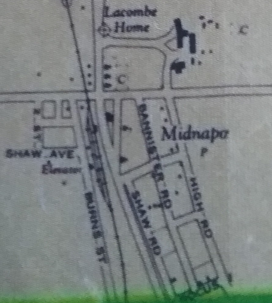
 Midnapore Surveying Map (1912) showing existing and planned roads southwest of present-day James McKevitt Road and Macleod Trail. Note Shaw Ave and Helen Ave, named after the Shaw family and family matriarch Helen Shaw. 2nd Street is present-day Millrise Boulevard; Burns Street is present-day 5th St SW. Photo credit: Don Dumais.
 The area shown in the surveying map through time. From left to right, 1912 map, 1926 aerial photo, 1969 aerial photo, 1982 aerial photo, 2015 satellite image. The original map was a plan for developing the area; the plots indicated were not in place at the time. The subsequent images show that the area did develop in a similar way to the original plan, before being largely redeveloped with a condo unit circa 2000.
“ All future development in or adjacent to the existing townsite should respect its history, character and strategic location.”- Midnapore I Design Brief (pg. 19)
Though the point of named streets is typically to pay tribute to local history and characters (again, I would recommend looking through What’s in a Name? by Donna Mae Humber for more of this), sometimes the history gets lost. Anderson Road for example, commemorates the Anderson family which homesteaded in the area; the neighbouring Halifax family argued in the book From Sodbusting to Subdivision, that their settlement in the area was at least as notable if not more so, and that the road could have just as easily been called Halifax Road.

When 146 avenue SW was renamed James McKevitt road in the late 1990s with vritually no fanfare or explanation, my parents laughed and wondered who James McKevitt was and why the name was changed. With no explanation or provided context, what does the name really mean? Well, since you may be wondering too, McKevitt was one of the earliest pioneers in the area, settling west of Midnapore and north of Red Deer Lake in 1884, and running a farm named Shamrock Hill with his wife Julia and 12 children until his death in 1931; the descendants of James and Julia McKevitt were also an integral part of the Midnapore town, and James McKevitt Road runs in the same area as the farm.
While I’m at it:
-Bannister Road is named after the Bannister family; William ‘Billy’ Bannister was the foreman of the Bow Valley Ranche in the Fish Creek Valley from 1896 to 1910.
-Macleod Trail is named after NWMP officer and Calgary founder Colonel James MacLeod; incidentally, the road also leads to the town of Fort Macleod, also named after the officer.
-Providence Boulevard, previously 146 Ave SE, east of 1 St SE, is named in reference to the Sisters of Providence, who have provided care in the Lacombe Home and surrounding institutions beginning in 1910
– Shaw Road in Midnapore refers to the storied Shaw family, referenced in the Community Names article, and whose descendants were heavily invested in local industry, business and St. Paul’s Church; the road originally lead to a property of theirs just south of St. Paul’s.
-Sheriff King Street, in Silverado, is named for the Alberta sheriff of the late 19th century, Peter Willoughby King, whose estate led to the creation of the YWCA Sheriff King home for abused women and children. King retired to a ranch near Calgary before passing away in 1922. I am unsure if the ranch was near Midnapore or Red Deer Lake, as Silverado is, but the man clearly had noble intentions, committed to providing “a home for deserving poor, both Women and Children” (Calgary’s Grand Story building a Prairie Metropolis, pg 36)
These named roads largely run like the east-west avenues or north-south streets, and take on the same numbering conventions, based on their position on the grid (hence, addresses like 14704 Bannister Road SE and 19369 Sheriff King Street SE). This is in great contrast to the suburban roads.
Suburban Streets

Yes, those much maligned suburban streets. Designed to work as mostly closed systems within the larger grid, with winding main drags, and a convoluted web of side streets, they serve to channel traffic to specific entrance and exit points and separate the residents, in particular wandering children, from the chaos outside. Not as intuitively modern as the grid of Streets and Avenues, the suburb design in Calgary is nevertheless the result of strong environmental psychology and urban planning, and this design is reflected in their naming. Robert M Stamp, in the book Suburban Modern, discusses how, to avoid confusion, street names in Calgary’s ever-multiplying suburbs would simply use the first letter of the community’s name to indicate location. As this later became impossible, due to, for example, Haysboro in the Southwest and Highwood in the Northeast, it was decided that street names would use the first three letters of the community as a prefix, along with its quadrant. Hence, all the street names like “Millside”, “Millcrest” and “Millbank” in Millrise or “Shawcliffe” “Shawbrooke” and “Shawinigan” in Shawnessy. Though it has been argued that this system makes the community names contrived and the street names boring, there is the point of making such a big, diverse city easier to navigate, particularly for taxi, truck and EMS drivers having to deal with far-flung, intricately designed suburbs.
This is an oversimplification of what the system is like in practice though. Street designs can have more subtle purposes, such as Somerset’s distinctive circular design with radiating side streets, reflected in its community emblem. And the designated prefix is not always so stringent, which explains why you can have both Shawnessy (“Sha-“) and Shawnee Slopes (“Shawnee-“) in the same quadrant. More than that, the prefix can be altered subtly, while the suffix and street name can provide further neighbourhood info and character.

Shawnessy has the best street names. There, more than anywhere else, the prefixes were used in clever ways. One I always liked was Shalom Way, used for the road providing access to the Jewish Beth Tzedec Memorial Park. The Shawville prefix, used for the roads in the community’s large commercial district on its east side, serves to highlight the district’s distinctiveness, while also giving a nod to local history; the west part of Midnapore, with a strong Shaw family presence, was reportedly once called Shawville. History is also reflected in the west side of the community, where the prefix is altered from the typical Shaw- to Shannon-, a nod to the Shannon family that resided in what is now the far west end of Fish Creek Park. Prefixes have been used for demarcation in other communities too: in Evergreen, the newer part of the community uses “Ever-“ while the older part, ‘Evergreen Estates’ north of James McKevitt and associated more with Shawnee Slopes, uses “Evergreen” in its street names.
 Signs for Midpark Boulevard, Sunpark Drive, Midlake Boulevard and Sunmills Drive, along Sunvalley Boulevard SE. Note the subtle differences in the street names.
The street suffix, all those “Glens” and “Vales” and “Meadows”, also from time to time provides some information about the area. A notable example is in Midnapore, where Midlake Boulevard is used to get to the lake, while Midridge Drive and Midvalley Drive go along the ridge of Fish Creek park, and are a means of viewing or accessing the park. Sundance similarly uses Sunvalley and Suncanyon in the northern part of the community, along the Fish Creek ridge, however its lake access roads have names like Sunmills Drive and Suncrest Way. And since I’m a nerd for this sort of thing, when I look at names like Shawglen Road or Midglen Way, I can’t help but see a missed opportunity: spelling them as Glenn could have been a nice nod to original area settler John Glenn and his descendants.
 Traffic Committee ad from Mid-Sun Messages newsletter, November 2015
Finally, there are the street types intended to give clues about the street’s purpose: “Boulevard” and “Drive” are meant to indicate traffic-heavy thoroughfares, while terms like “Crescent”, “Place” and “Gardens” are heavily residential and often dead-ends. Of course, there can still be some confusion for drivers, like in the case of Sunvalley Boulevard, the name for 162 ave in the SE, which leads into Sundance right off the highway. The indication provided by the road name, that you are entering a residential suburb, has all too often failed as a traffic-calming measure, and the area is still prone to accidents and heavy speeding from drivers who fail to effectively slow down after leaving Stoney Trail. This is a major problem since the road cuts right through Sundance, and requires plenty of pedestrian crosswalks for nearby schools. It is a tough example of the best intentions of planning meeting the realities of development, place and human behaviour. Just like the cases of named roads being a nice touch, while often failing to provide meaningful history, these residential street names do not always work as intended. As a city like Calgary continues to grow, we can expect there will be more designs of layout attempted, and all we can hope for is that they build on past mistakes. For the rest of it, we have to do all we can to improve the areas that are lacking.
Some maps from the 1960s and early 1970s provide some more street names for old Midnapore:
http://thedeepsouth.ca/wp-content/uploads/2017/09/MidnaporeMap_1970s.jpg
http://thedeepsouth.ca/wp-content/uploads/2017/09/MidnaporeMap_1970s2.jpg
153 Ave was Crocus Road
151 Ave was Short Road
149 Ave was Edwards Road, and previously connected up to 1st Street, which was known as High Road
Present-day Millrise Boulevard was 2nd St, but the numbered streets also got muddy over the years, with 5th street SW, aka Burns St, sometimes called 4th St. The north end of Shaw Road (misspelled Show Road in some maps) was also called 4th St at times. This was especially egregious since this was where the road terminated and got it’s name, with the old Shaw home at the southwest corner of 146 Ave and Shaw Road. It is unclear where Crocus, Short, Edwards or High Roads got their names from.
Bringing up these names with former residents, it seems they were not commonly used, but must have been official enough to make these maps.
As I noted, Sun Valley Boulevard (162 Ave) has been a challengin road in the area. Since it comes right off the highway, speeding is an issue, and even the speed limit of 60 km seems inappropriate for a road that splits a community in two. Ironically, this would not have been the case if the northern part of Sundance had been developed as part of Midnapore, as was originally planned, but the danger remains.
A group of residents near Sun Valley Boulevard has worked extensively over the years to improve the road, both independently and with the Mid-Sun Community Association. Some of their initiatives were better crosswalks on the road, and getting an additional community sign installed on the north side of the road, with the byline “Please Drive Safely”.
Years ago the committee put together a website and gallery for accidents and concerns along Sun Valley. Though the group’s work has continued, the website has not been updated in some time. Still it is a unique online artifact, showcasing some of the history of activism in the community. Here is the link:
http://sunvalleyblvd.webs.com/